The digital revolution in urban transportation has fundamentally transformed how residents navigate Tokyo’s labyrinthine transit system, with smartphone applications becoming indispensable tools that reshape daily movement patterns and decision-making processes. For sharehouse residents in particular, these technological innovations have created entirely new paradigms for exploring the city, managing commute times, and integrating into local communities through enhanced mobility confidence and accessibility.
The profound impact of transportation applications extends far beyond simple route planning, influencing everything from residential location choices to social interaction patterns and economic spending behaviors. Understanding these transformative effects provides valuable insights into modern urban living dynamics and helps sharehouse residents leverage technology for optimal city navigation experiences.
The Digital Transformation of Urban Navigation
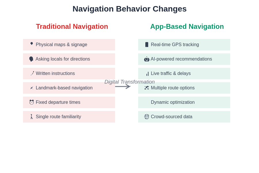
Traditional navigation methods in Tokyo relied heavily on physical maps, station signage, and local knowledge that often created barriers for international residents and newcomers to the city. The emergence of sophisticated transportation applications has democratized access to Tokyo’s complex transit network, enabling users to navigate confidently regardless of language proficiency or local familiarity.
Modern transportation apps integrate real-time data streams, machine learning algorithms, and user-generated content to provide dynamic routing recommendations that adapt to changing conditions throughout the day. This technological sophistication has created a fundamental shift from static, predetermined travel patterns to flexible, optimized journey planning that responds to live traffic conditions, service disruptions, and alternative route opportunities.
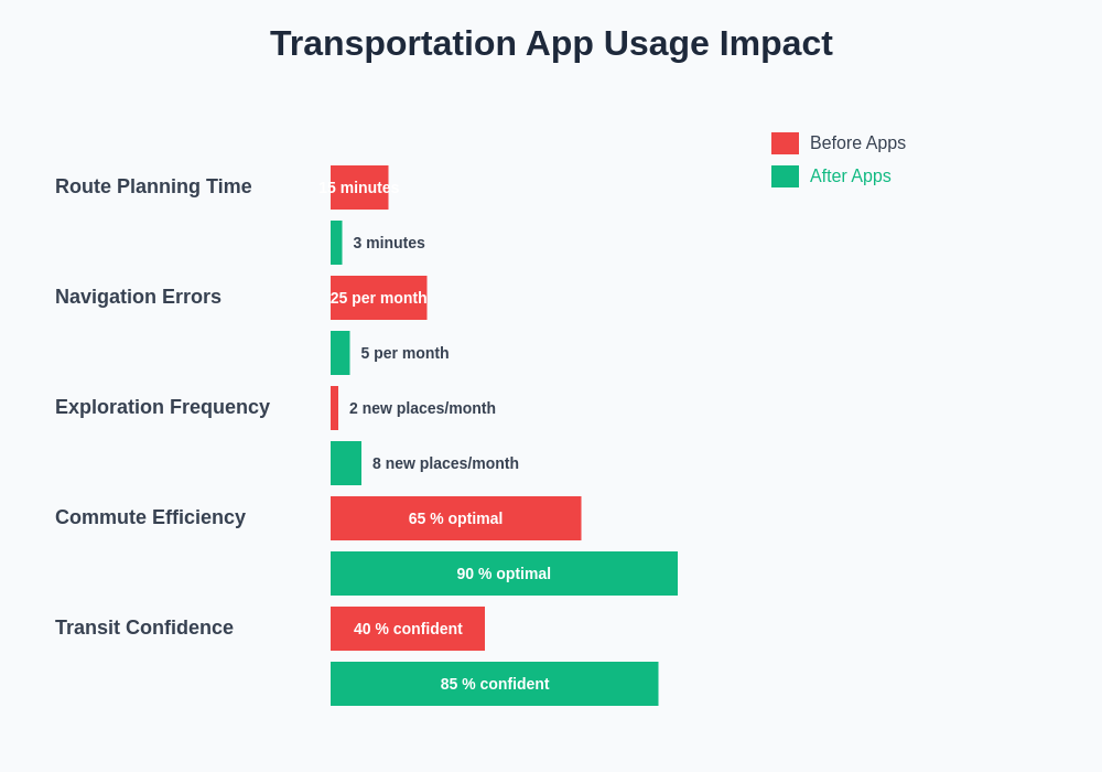
How commute times impact your quality of life demonstrates the critical importance of efficient navigation for sharehouse residents who often prioritize location accessibility when selecting accommodation. Transportation apps have become essential tools for evaluating potential living situations and maintaining optimal work-life balance through intelligent route optimization.
The integration of multiple transportation modes within single applications has particularly benefited sharehouse communities, where residents frequently combine walking, cycling, train travel, and occasional taxi usage to reach various destinations throughout Tokyo’s sprawling metropolitan area.
Behavioral Changes in Route Selection and Planning
Transportation applications have fundamentally altered decision-making processes related to route selection, with users increasingly relying on algorithmic recommendations rather than developing personal familiarity with specific paths or transportation corridors. This shift has created both opportunities and dependencies that significantly impact daily navigation habits and spatial knowledge development.
The instant availability of multiple route options with comparative timing, cost, and transfer information has encouraged more adventurous and experimental travel behaviors among sharehouse residents. Users now regularly explore alternative paths, discover new neighborhoods, and optimize their journeys based on real-time conditions rather than adhering to familiar routines.
Real-time adaptation capabilities enable dynamic route adjustments that respond to service delays, crowd conditions, and weather factors, creating more resilient and flexible travel patterns. How weather affects transportation choices explores how environmental conditions influence navigation decisions and app usage patterns throughout different seasons.
The predictive features of modern transportation apps have also transformed planning behaviors, with users able to anticipate optimal departure times, identify peak congestion periods, and schedule activities around transportation efficiency considerations. This enhanced planning capability has particularly benefited sharehouse residents who coordinate complex schedules involving work, social activities, and community commitments.
Impact on Spatial Knowledge and City Familiarity
The reliance on digital navigation tools has created interesting paradoxes in spatial knowledge development, with some users developing extensive familiarity with Tokyo’s transportation network while simultaneously losing connection to geographic relationships and landmark-based navigation skills. This phenomenon has particular implications for sharehouse residents who may become highly efficient at reaching specific destinations while lacking broader understanding of neighborhood relationships and urban geography.
Transportation apps tend to prioritize efficiency over exploration, potentially limiting organic discovery of neighborhoods, local businesses, and cultural attractions that contribute to deeper city integration and community connection. How to find perfect sharehouse tokyo emphasizes the importance of neighborhood familiarity in housing decisions, highlighting potential conflicts between app-guided efficiency and comprehensive area knowledge.
The compartmentalization of urban experience through app-mediated navigation can reduce serendipitous encounters and spontaneous exploration that traditionally contributed to cultural immersion and local community integration. Sharehouse residents may find themselves efficiently moving between predetermined destinations without developing the peripheral awareness and environmental sensitivity that enhance urban living experiences.
However, some transportation apps now incorporate discovery features, points of interest recommendations, and community-generated content that can partially compensate for the reduction in organic exploration while maintaining navigational efficiency and route optimization benefits.
Social and Community Integration Effects
Transportation app usage patterns significantly influence social interaction opportunities and community integration processes for sharehouse residents navigating Tokyo’s complex urban environment. The confidence enabled by reliable navigation tools encourages more frequent social activities, cultural event attendance, and neighborhood exploration that contributes to richer community engagement experiences.
The ability to easily coordinate meetups, share location information, and navigate to unfamiliar venues has expanded social circles and activity participation among sharehouse communities. Making friends through tokyo sharehouse communities highlights how transportation accessibility affects social relationship development and community participation levels.
Collaborative navigation features enable shared journey planning, group coordination, and real-time location sharing that enhance safety and social connection during group activities and late-night transportation. These capabilities have become particularly valuable for international residents who may feel uncertain about navigating Tokyo’s complex transit system independently during evening hours.
The integration of social features within transportation apps has also created new forms of community knowledge sharing, with users contributing real-time information about service conditions, accessibility features, and local insights that benefit broader sharehouse networks and international resident communities.
Economic Implications of App-Driven Navigation
Transportation applications have created significant economic impacts on sharehouse residents’ spending patterns, budget allocation decisions, and overall financial management strategies related to mobility costs and location-based expenses. The transparency of route costs, timing comparisons, and alternative transportation options enables more informed decision-making about daily travel expenditures.
Dynamic pricing information and cost comparison features help users optimize transportation budgets by identifying the most economical route combinations for different trip types and timing scenarios. How transportation costs impact entertainment budgets explores the relationship between mobility expenses and discretionary spending decisions that affect quality of life for sharehouse residents.
The ability to accurately predict and plan transportation costs has influenced residential location decisions, with potential sharehouse residents able to calculate comprehensive mobility expenses for different neighborhoods and property options. This enhanced cost visibility has shifted some residential preferences toward areas with optimal transportation cost-efficiency ratios rather than simply proximity to central districts.
Transportation apps have also enabled more strategic timing decisions that take advantage of off-peak pricing, special promotions, and alternative transportation modes that reduce overall mobility costs while maintaining accessibility to employment, education, and social opportunities throughout Tokyo.
Technology Dependence and Resilience Considerations
The increasing reliance on smartphone applications for navigation has created both enhanced capabilities and potential vulnerabilities that affect sharehouse residents’ urban mobility resilience and independence. Device battery life, internet connectivity, and application functionality have become critical factors in daily transportation planning and execution.
Technical failures, service outages, or device malfunctions can leave app-dependent users significantly disoriented and unable to navigate effectively, particularly in unfamiliar areas or during emergency situations. This dependency highlights the importance of maintaining backup navigation skills and alternative information sources for resilient urban mobility.
The rapid pace of application updates, interface changes, and feature modifications can disrupt established navigation routines and require continuous adaptation from users who have integrated these tools into daily workflows. How digital entertainment replaces social interaction touches on broader technology dependency issues that parallel navigation app reliance patterns.
Network connectivity requirements in subway systems, underground areas, and building interiors can create navigation gaps that affect seamless journey completion and real-time route optimization capabilities. Sharehouse residents often develop hybrid navigation strategies that combine digital tools with traditional wayfinding skills to maintain mobility resilience across different scenarios.
Cultural and Language Accessibility Improvements
Transportation applications have dramatically improved navigation accessibility for international sharehouse residents by providing multilingual interfaces, visual navigation cues, and cultural context that bridges language barriers and reduces navigation anxiety in Tokyo’s complex urban environment.
Real-time translation features, phonetic pronunciation guides, and visual station identification tools have enabled confident navigation for residents with limited Japanese language proficiency. How language barriers complicate legal documents demonstrates similar accessibility challenges that transportation apps help address in mobility contexts.
Cultural integration features such as etiquette reminders, local custom explanations, and appropriate behavior guidance help international users navigate not just physical routes but also social expectations and cultural norms associated with Tokyo’s transportation systems. These educational components contribute to smoother community integration and reduced cultural friction during daily travel experiences.
The standardization of navigation interfaces across different cultural backgrounds has created common reference points that facilitate communication and coordination among diverse sharehouse communities, enabling more effective shared planning and collaborative exploration activities.
Privacy and Data Considerations
The extensive location tracking, movement pattern analysis, and personal data collection inherent in transportation app usage raise important privacy considerations that affect sharehouse residents’ digital security and personal information management strategies.
Location history data, travel pattern analysis, and predictive modeling capabilities provide valuable services but also create comprehensive profiles of users’ daily routines, social connections, and lifestyle preferences that may have broader implications for privacy and personal security.
Data sharing between transportation apps, advertising networks, and third-party services can result in extensive personal information distribution that users may not fully understand or control. How personal information gets compromised addresses broader digital privacy concerns that apply to navigation app usage patterns.
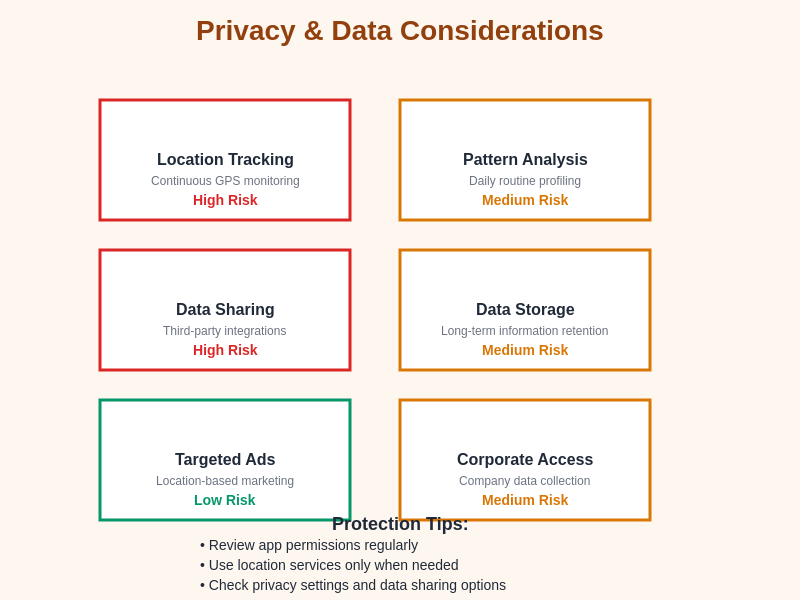
The balance between personalized service quality and privacy protection requires careful consideration of application permissions, data sharing settings, and usage patterns that protect personal information while maintaining access to beneficial navigation features and real-time optimization capabilities.
Future Developments and Emerging Trends
The evolution of transportation applications continues to accelerate with emerging technologies such as augmented reality navigation, predictive analytics, and integrated mobility-as-a-service platforms that promise to further transform urban navigation habits and sharehouse living experiences.
Augmented reality features that overlay navigation information onto real-world views through smartphone cameras are beginning to provide more intuitive and contextual guidance that reduces the cognitive load of translating digital maps into physical movement decisions.
Integration with smart city infrastructure, Internet of Things sensors, and predictive analytics systems will enable even more sophisticated route optimization that anticipates conditions, preferences, and constraints to provide seamless mobility experiences for urban residents.
The development of unified mobility platforms that integrate public transportation, ride-sharing, bike-sharing, and walking navigation into single applications will further simplify travel planning and execution while optimizing for multiple objectives including cost, time, environmental impact, and user preferences.
Strategies for Balanced Navigation Approach
Successful integration of transportation apps into sharehouse living requires balanced approaches that leverage technological advantages while maintaining spatial awareness, exploration opportunities, and resilience capabilities that contribute to comprehensive urban navigation competency.
Periodic disconnection from navigation apps during familiar routes can help maintain and develop spatial knowledge, landmark recognition, and environmental awareness that contribute to deeper city understanding and navigation independence.
Combining app-guided efficiency with deliberate exploration activities creates opportunities for neighborhood discovery, cultural immersion, and community connection that purely optimized routing might miss. How to handle roommate conflicts without moving out suggests similar balanced approaches to managing technology integration in communal living situations.
Developing backup navigation skills, maintaining offline map capabilities, and practicing traditional wayfinding techniques ensures resilience during technical failures while preserving the cognitive and spatial skills that contribute to comprehensive urban competency and confidence.
The transformation of navigation habits through transportation applications represents a fundamental shift in how sharehouse residents experience and interact with Tokyo’s urban environment. While these tools provide unprecedented accessibility, efficiency, and confidence in city navigation, thoughtful integration that balances technological dependence with traditional skills and exploration opportunities creates the most rewarding and resilient urban living experiences. Understanding these dynamics enables sharehouse residents to leverage navigation technology effectively while maintaining the spatial awareness and cultural engagement that contribute to meaningful city integration and community participation.
Disclaimer
This article is for informational purposes only and does not constitute professional advice regarding technology usage or urban navigation strategies. Transportation app features, availability, and functionality may vary and change over time. Users should exercise caution and maintain awareness of their surroundings when using navigation technology. The effectiveness of navigation strategies may vary depending on individual circumstances, technical proficiency, and specific urban environments.